


2021-07-05_21h42m41_tour-du-taillefer-en-7-jours

claude nier
User
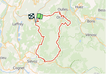

Length
77 km

Max alt
2110 m

Uphill gradient
4046 m
Km-Effort
131 km

Min alt
798 m

Downhill gradient
4048 m
Boucle
Yes
Creation date :
2021-07-05 19:42:42.135
Updated on :
2021-07-06 04:13:41.452

FREE GPS app for hiking
 SityTrail
IGN / Geographical institutes
SityTrail Plus
The world is yours!
About
Trail of 77 km to be discovered at Auvergne-Rhône-Alpes, Isère, La Morte. This trail is proposed by claude nier.
Positioning
Country:
France
Region :
Auvergne-Rhône-Alpes
Department/Province :
Isère
Municipality :
La Morte
Location:
Unknown
Start:(Dec)
Start:(UTM)
725049 ; 4990089 (31T) N.
Comments